Dec 20, 2023
Your next learning opportunity has arrived. Qt Academy and Esri present to you our new Customer Featured Learning Path: Exploring with ArcGIS Maps SDK for Qt.
In case you’ve somehow missed it, Qt Academy is our free eLearning platform, where code meets creativity. There is a multitude of free online courses spanning a variety of topics and Qt-built technologies—anywhere from the beginning levels of learning to code with Qt, to more in-depth, advanced courses. Our users span many different industry backgrounds and universities around the world. Whether you’re a student, teacher, career-changer, or just someone interested in learning a new framework, our learning platform is easy to follow and will take you as deep as you’d like to go.
Who and What is Esri?
Esri is the world's leading supplier of geographic information system (GIS) software, web GIS, and geodatabase management applications. The company was established in 1969 and is widely recognized for advancing the power of geography in business, government, and society. Their flagship product, ArcGIS, is a comprehensive suite of GIS software that provides various tools for mapping and spatial analysis.
Not only is their technology impressive, but it is also being used to solve some of the world's most complex problems. Business and government leaders worldwide rely on Esri's technology to understand and address significant challenges such as climate change, public health, supply chain resilience, and social equity.
What are Geographic Information Systems?
Geographic Information Systems (GIS) are computer systems that help create, manage, analyze, and map all types of data. GIS connects location data, where things are, with descriptive information, what things are like there, providing a foundation for mapping and analysis that is used in science and almost every industry. By understanding patterns, relationships, and geographic context, GIS helps users make better management and decision-making decisions, thus improving communication and efficiency.
ArcGIS is Esri’s powerful GIS that provides access to a vast collection of curated datasets and maps. These resources can be analyzed and leveraged to gain insights. The platform can be used on desktops, mobile devices, and in the cloud to create a variety of items, such as maps, apps, dashboards, 3D scenes and models, and data science notebooks.
The Learning Path and Online Courses
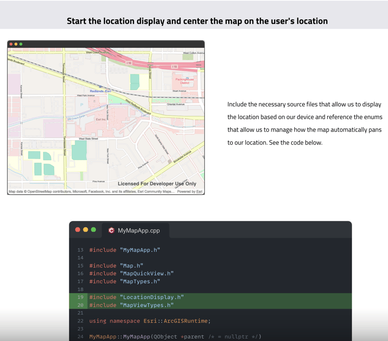
In this learning path, you will be introduced to the ArcGIS Maps SDK for Qt, a set of tools and APIs provided by Esri, designed for building mapping and GIS applications using the Qt framework. Throughout the path you will learn how to set up a simple hiking application that displays the user's location, displays their path as they move around, and implements the ability to download a specified area for offline accessibility.
The learning path is designed for individuals with some C++ and QML knowledge. We encourage you to come prepared by completing the Ready, Set, Qt! learning path first to get set up with Qt Creator and the Framework if you are not yet familiar.
With basic Qt knowledge at hand, this learning path should take approximately a total of 2-3 hours to complete across 4 courses. In the end, you will have an app to explore, adapt, and build upon for a personal project or portfolio piece. Digging into each of the courses you will find:
-
Setting Up ArcGIS Maps SDK for Qt: Learn how to get set up with the ArcGIS Maps SDK for Qt and get ready to build mapping and spatial analysis applications.
-
Plot Your Path: Learn to display a visual indication of your location history on a map.
-
Download a Map Area: Learn how to create an offline map by specifying the area you want to take offline and save the map to your device.
-
Display an Offline Map: Learn how to take an offline map vector tile cache and then display this within an application so it can be used without a network connection.
-1.png?width=1731&height=1444&name=MicrosoftTeams-image%20(35)-1.png)
Want to interact with other learners? You can find an open discussion in the Qt Forum here. We encourage you to describe the app you're working on during this course and to share any feedback or support you may need. This is an open forum for discussion and assistance in enhancing your learning experience.
So, what are you waiting for? Get ready to dive in. You can sign up for Qt Academy and enroll in the Exploring with ArcGIS Maps SDK for Qt learning path here.